NA-M027 SD Card Format Central America & Car
Model: NA-M027 Brand: C-Map
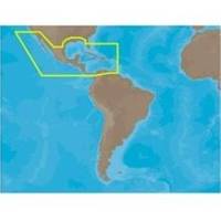
NA-M027 => Central America and CaribbeanCoverage of Central America, all of the Caribbean and the northern coast of South America, and the Gulf of Mexico. Coverage of the Pacific coast starts at Point Conception, CA and runs down to Bahia Cupica, Colombia. Coverage of the United States starts in Cumberland Sound, GA and runs down around Florida and over to Brownsville, TX. Bahamas, Turks and Caicos and all islands of the Caribbean are included. South American coverage includes the northern coasts of Colombia and Venezuela over to Rio Orinoco, including Trinidad and Tobago. Caribbean coverage includes charts from Explorer Chartbooks and Wavey Line Publising. « less
Product Specification
-
Universal Product Identifiers
Part Numbers: 30146, M-NA-M027, NA-M027-SD, NA-M027 SD CARDGTIN: 00686074002807
Related Products
-
Chart Master V6i #U1-CHRT-V6i
-
Package(C120W, 4KW 24 Inch Digital Radome & Radar Cable)
-
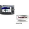
GP1041 Pre-Cut F/ Raymarine C70 & One ST60 Instrument
-
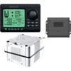
AP2801VRF Autopilot AP28, ac12, RC42 No Drive Unit
-
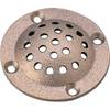
5" Round Bronze Strainer Made in The USA
-
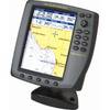
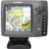
700 Series 788ci Combo CHO - Marine Chartplotter - 5" color - 640 x 640
-
Cat6a Ethernet Cable | 2ft | Orange | Network | 10 Gigabit
-
Shore Power Cable 6/4 White Per ft
-
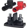
Power Post Dual 2 x 5/16 in. Studs
-
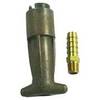
18-8083 3/8 in. Fuel Connector
-
Whisper 50' Guyed Tower Kit (Whi100/Whi200) (does Not Include Pipe & Anchors)
-
14ft 24AWG Cat6 550mhz UTP Ethernet Bare Copper Network Cable - White