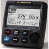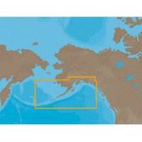
NA-C802 Furuno FP Format Gulf of Alaska
Model: NA-C802 Brand: C-Map
With are Electronic Sharts C-Maps we have: Olympia, Washington to Port Mcneill, British Columbia. Nannose to Victoria to Cape Scott Texada Island to Caamano Sound Cape Caution to Portland Canal Banks Island, British Columbia to Sumner Strait, Alaska Dixon Entrance to Icy Bay Gulf of Alaska Western Alaska NA-C802 Gulf of Alaska NT+ Cartography NT+ electronic charts feature much wider coverage areas at substantially lower prices. « less
Product Specification
-
Universal Product Identifiers
Part Numbers: 20185, NA-C802, NA-C802FURUNOFPGTIN: 00686074002258
Related Products
-
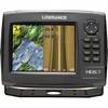
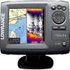
HDS-7 Gen2 Fishfinder GPS Chartplotter 53518700
-
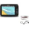
Package(c95 with aus, NZ, S. America, Asia Chart, 4KW 18 Inch Digital Radome & Radar Cable)
-
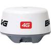
4G Broadband Radar Dome with 20m Cable c42562
-
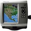
GPSMAP 530 - Marine GPS receiver - 4" color - 240 x 320
-
Canadian Charts Qu.Charlot Str.W.Portion/Bull Harb.
-
Navpilot700ob Autopilot Outboard Requires Pump
-
Series 50 Classic Stainless Steel Navigation Lights
-
Chartwork and marine navigation for fishermen and boat operators [Book]
-
Elite 5 5" 83/200kHz Chartplotter/Fishfinder
-
Cat6a Ethernet Cable | 5ft | Blue | Network | 10 Gigabit
-
50ft 24AWG Cat5e 350MHz UTP Bare Copper Ethernet Network Cable - White
-
Cat6a Ethernet Cable | 75ft | White | Network | 10 Gigabit