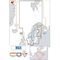
Max Electronic Chart, Wide, South-West European Coasts, DVD, M-EM-M076
Model: M-EM-M076 Brand: C-Map
Mfr: C-MAP Electronic Charts - EM-M076; For a detailed list of coverage areas and map changes, visit C-Map . Bring your electronic charts to life with MAX, the ultimate navigator. C-MAP Max was built on the incredible success of C-MAP NT+ (voted Best Electronic Charts by the NMEA for 6 consecutive years) and provide you access to lightning fast, knockout performance plus real-life accuracy and detail. Photos and Diagrams C-Map by Jeppesen charts are full of extra value added data. High definition photographs of ports & singificant navigational aids make navigation that bit easier by allowing a mariner to enter a port, even without having been there previously, in full confidence after having seen detailed photographs and diagrams of it. Points of Interest and Road Mapping When pulling into port, why not look to your C-Map by Jeppesen chart to guide you? C-Map charts will allow for the most to be made of a visit inland with the road coverage so as to allow planning. Tidal Predictions The ability to know the tidal heights of the water is an important element in planning any route and one that remains so during its navigation. Their dynamic display on C-Map charts makes this data accessible to all boaters. Guardian Alarm Guardian Alarm is an exclusive tool that allows you to sail in safety. This function will automatically detect potential dangers whilst you are planning and navigating. Customisable to your boat and needs, you can enjoy your sailing and relax, safe in the knowledge that you have Guardian Alarm on lookout. C-Map charts contain detailed plans for every port, haven and harbour allowing you to view a large scale and accurate view of the landings. Perspective View This option gives you a possibility to change perspective while using the chart. All the other chart features will be visible just the same and you will gain a view similar to the one in reality. An alternative viewpoint without compromising functionality « less
Product Specification
-
Universal Product Identifiers
Part Number: EM-M076
Related Products
-
E62186US E62186-US E62186 US A50D 5" Fishfinder - Chartplo
-
GPS receiver marine swivel mounting bracket
-
LED Bicolor Light White 12V/24V ASL-341017
-
Marine Navigation and Safety of Sea Transportation [Book]
-
Manhattan iLynk 2-in-1 Cable - iPad / iPhone / iPod / cellular phone charging / data cable kit
-
20110003 SP-36 Second Station Kit W/25' Cable
-
25ft Premier Series XLR Male to 1/4inch TRS Male 16AWG Cable (Gold Plated)
-
Fuel Line Connector Johnson Evinrude Male Fitting 2-Prong
-
Lumishore Thru Hull Flush Fit 18 Watt Green Underwater Light 41681
-
14ft 24AWG Cat6 550mhz UTP Ethernet Bare Copper Network Cable - White
-
VHF 200 25W VHF Radio 010-00755-00
-
355 2 Conductor Start Interlock Cable
