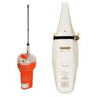
JQE-103 EPIRB System
Model: JQE-103 Brand: jrc
Emergency Transmissions To comply with GMDSS regulations vessels must carry a satellite EPIRB. During critical situations the EPIRB will be released and activated, either automatically or manually. Once activated, the EPIRB will transmit vessel specific information on 406MHz that is passed, via satellite, to the RCC. This information is used to commence SAR operations and with search aircraft monitoring the 121.5MHz transmissions enables the EPIRB to be located. Additionally, if a situation occurs where it is required to throw the EPIRB overboard, the hardened outer shell will remain intact after a drop onto the water surface from a maximum 20 meter height. Release Bracket Safety measures are taken to prevent faulty signal transmissions. The self-deploying automatically activates when the beacon floats to the surface." In the event of distress the beacon can also be activated manually by a simple switch operation. JRC distinguishes itself in having the automatic release bracket included as standard. Improved battery life of the JQE-103 extends the first replacement up to 5 years. JRC? s advanced water pressure sensor has a replacement period of up to 2 years. IMO compliant The JQE-103 complies with IMO MSC.152 (78) carriage requirements. In addition, JRC is continuously developing and evaluating new products based upon future IMO requirements that will contribute for your future safety and navigation at sea. Satellite EPIRB The satellite EPIRB will be automatically released from its float-free bracket when subjected to water pressure at less than 4 meter depth, and will float up to the surface. Upon contact with sea water, it will activate itself and transmit emergency signals for at least 48 hours, coinciding with a repeated flashing light. The emergency transmission includes a digitally encoded message, containing ship's position, identity and nationality. « less
Product Specification
-
Universal Product Identifiers
Part Number: jqe-103
Related Products
-
AP5005 Autopilot with AP50, J50, Rudder Feedback RF300, RPU300-12V Drive Unit
-
Package(e127 with aus, NZ, S. America, Asia Chart, 4KW 18 Inch Digital Radome & Radar Cable)
-
RS-C209 Furuno FP Format - White Sea Barents Sea E Fish
-
Rockport to Bangor, Maine Nautical Marine Charts - Waterproof Charts
-
Waterproof Chart Kit - Cape Ann Mass. to Portalnd, Maine
-
010-C0764-10 Bluechart G2 HEU005RIreland West Coast Data Card
-
90 Marine Navigation ParaLock Plotter
-
Orca Green Marine LED Tri-Color Anchor / Strobe Navigation Light
-
Dvid 10M Cable FNavnet 3D
-
15ft 28AWG DisplayPort Cable - White
-
T-H Marine Lj-3420501 Male Battery Charger Plug Red
-
2ft 24AWG Cat6 550mhz UTP Ethernet Bare Copper Network Cable - Gray
