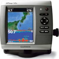
GPSMAP526S Color Combo SOUNDER/GPS w/Transducer
Model: GPSMAP526S Brand: Garmin
The GPSMAP 526 is a compact chartplotter that features a high-resolution, super-bright 5? VGA display along with an improved high-speed digital design for increased map drawing and panning speeds. Its ready to go with a built-in, satellite-enhanced worldwide basemap. The GPSMAP 526 also accepts Blue - Chart g2 Vision cards for added features and functionality such as high-resolution satellite imagery, 3-D views and Auto Guidance technology. Explore the Seas The GPSMAP 526 comes ready to go with a worldwide basemap with satellite images in place of more traditional maps. The GPSMAP 526 also comes standard with a high-sensitivity GPS receiver for superior satellite tracking and quicker acquisition times. In addition, the GPSMAP 526 can receive U.S. graphical weather data via optional GXM 51 satellite receiver/antenna. And with an SD card slot, its easy to add additional maps without connecting to a computer. Add Sonar Where applicable, the sounder version, GPSMAP 526s, comes with a powerful dual-frequency transducer that clearly illustrates depth contours, fish targets and structures whether youre fishing in freshwater or off the coast. The GPSMAP 526 and GPSMAP 526s are also NMEA 2000-certified for easy connectivity with sensors, instruments and future marine offerings. Add Extras with Blue - Chart g2 Vision With the optional Blue - Chart g2 Vision SD card, you can add a whole new dimension of exceptional features to your chartplotter. - Eye view and Fish - Eye view provide you a 3-dimensional perspective of map information, both above and below the waterline. High-resolution satellite images and aerial photographs help you orient yourself in unfamiliar areas. - H: 3.0" x 4.0", 5.0" diagonal (7.6 x 10.2 cm, 12.7 cm diagonal) Display resolution, Wx - Chart g2 Vision card) Auto Guidance: yes (with optional Blue - Chart g2 Vision card) XM WX Weather & Radio for U.S. & Canada compatible: yes Automatic routing (turn by turn routing on roads): no Voice prompts (e.g. "Turn right in 500 ft."): no Speaks street names (e.g. See versions for details. Name Sku GPSMAP 526 010-00772-00 GPSMAP 526s (with dual-frequency transducer) 010-00772-01 GPSMAP 526s (no transducer) 010-00772-02 « less
Product Specification
-
Universal Product Identifiers
Part Number: GAR0100077201
Related Products
-
AP5009 Autopilot with AP50, J50, Rudder Feedback RF300, HLD350
-
JMA-5104 Black Box Radar 48 NM with 4KW 24 Inch Dome without Display
-
010-00756-01 VHF 300i Marine Radio
-
USA 010-11001-50 Topo US 2008 landmarine Map
-
Orca Green Marine LED Masthead / Anchor Navigation Light 9385337
-
Fiber Optic Cable, LC/ST, Multi Mode, Duplex - 3 Meter 2623
-
LTD A3030Y50H 50 Amp to 30 Amp Y-Adapter
-
M5100C9R 100A 30Y 120/208V Female Connector
-
527ID-IHN M260 In-Hull 1kW Transducer W/No Connector
-
2205 Black Terminal Feed Through Connector
-
Marine Products Plug Wire Set 9-28043
-
1100 Series 1155c - Marine Chartplotter - 10.4" color - 800 x 600
