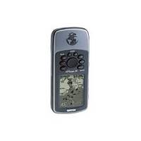
GPSMAP 76 - Marine, hiking GPS receiver - Monochrome - 240 x 180
Model: 240 Brand: Garmin
The GPSMAP 76 is designed to provide precise GPS positioning using correction data obtained from the Wide Area Augmentation System. This unit features a built-in quad helix antenna for superior reception and can provide position accuracy to less than three meters when receiving WAAS corrections. The GPSMAP 76 has an internal memory capacity of eight megabytes. In addition, it comes with a built-in basemap of cities, coastlines, lakes, rivers, interstates, and interstate exit information and a database of nautical navaids. This unit has eight megabytes of internal user memory for storing optional MapSource - detailed maps, including marine cartography. This memory is preloaded from the factory with worldwide cities (populations greater than 200, 000) and nautical navigation aids such as lights, buoys, sound signals and day beacons. The GPSMAP 76 is also preloaded with tide data for the United States. An extra-large display measuring 1.6"W x 2.2"H gives users a clear view of information, while a waterproof case means the GPSMAP 76 will keep working well even if it has been submerged in water. Even more amazing, this unit will actually float if accidentally dropped in the water. « less
Product Specification
-
General
Product Type: GPS receiverRecommended Use: Marine, hikingPreloaded Maps: South America, Canada, USA, Alaska, Central America, MexicoReceiver: 12 channelInterface: Serial, NMEA 0183, RTCM SC-104 DGPSIncluded Software: Garmin Marine Point Database (Americas), Garmin Americas Highway BasemapGrids: UTM, MGRS, Lat/Lon, UPS, Loran TDs, MaidenheadSBAS: WAASDGPS: DGPS readyAntenna: Built-inAccuracy: Position - 49 ft Position - 10 ft - 16 ft ( with DGPS ) Position - 10 ft ( with WAAS ) Velocity - 0.16 ft/secUpdate Rate: 1/secondInternal Memory: 8 MB flashFirst Seen On Google Shopping: May 2003 -
Display
Type: LCD - monochromeResolution: 240 x 180Display Illumination: Yes -
Acquisition Times
Warm: 15 secCold: 45 sec -
Navigation
Waypoints: 500Tracklog Points: 2048Routes: 50Waypoints per route: 50Trip Computer: TracBack -
Battery
Type: AA typeRequired Qty: 2Run Time (Up To): 16 hours -
Miscellaneous
Protection: WaterproofWaterproof Standard: IPX7Localization: English -
Dimensions & Weight
Width: 2.7 inDepth: 1.2 inHeight: 6.2 inWeight: 16 oz -
Manufacturer Warranty
Service & Support: 1 year warranty -
Environmental Parameters
Min Operating Temperature: 5 °FMax Operating Temperature: 158 °F -
Universal Product Identifiers
Part Numbers: 010-00249-00, 76GTIN: 00753759029616
Related Products
-
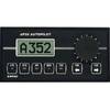
AP-35 Pack 2 Pilot AP35,J300X,RF300,RC25
-
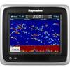
A67 Mfd Touchscreen wbuilt in Sonar No Charts E70077
-
e7D 7" Multifunction Display with Sonar, Internal GPS, USA Silver Charts, RD418D Radar & No Transducer T70103 c44594
-
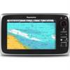
E70011 C95 Multifunction Display - No Charts Preloaded
-
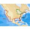
BlueChart g2 Vision - South Maine - Maps
-
CFFISHW Map, USA Fish N Chip West & Gulf
-
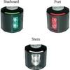
Series 43 White LED Navigation Light Port
-
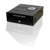
Marinenav Leviathan Marine Navigation PC Computer LEV-017R-Intel
-
USB cable - 9 pin USB Type A - M - 9 pin USB Type B - M - 6 ft - PC
-
A06064 - SeaTalk NG 5-Way Connector Block
-
MU-170C 17 Color LCD Monitor w/o Bracket
-
1ft 24AWG Cat5e 350MHz UTP Bare Copper Ethernet Network Cable - Green