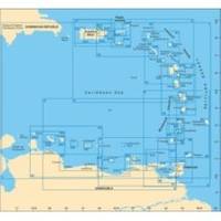
D232 Imray Curacao Marine Nautical Chart
Model: D232 Brand: Weems And Plath
This Imray-Iolaire waterproof chart details the island of Curacao. It includes large scale insets of Willemstad and Schottegat Piscaderabaai Santa Marta Baai and Spaanse Water. This color chart is flat with no folds so is suitable for framing. Dimensions: 25 x 35 1/2 (640 x 900 cm). « less
Product Specification
-
Universal Product Identifiers
Part Number: D232
Related Products
-
AP5001 Autopilot with AP50, J50 (12 Amps), Rudder Feedback RF300
-
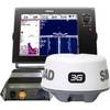
NSS12 Navigation Pack - NSS12, 3G Radar BSM-1
-
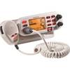
Mr F75-D Marine Class-D Digital Selective Calling Technolog
-
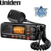
Class D DSC Marine Radio Um380-bk PP3090
-
Methods and Algorithms in Navigation: Marine Navigation and Safety of Sea Transportation [Book]
-
50PC50 50 Amp - 125VAC 50 Foot Cable Cord Set (Yellow)
-
10ft 28AWG High Speed HDMI Cable w/Ferrite cores - Black
-
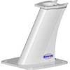
6812 Vision Series Modular System Mount / Pedestal
-
YQ100PLUS - Adapter Cord Set, 125/250V, Yellow
-
ZDIGUSBNMEA NMEA Adapter
-
IC-M88 VHF 22-channel Two-way radio
-
GPSMAP 3010c - Marine GPS receiver - 10.4" color - 640 x 480