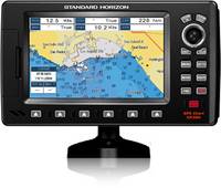
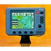
CP390iNC
Model: CP390iNC Brand: Standard Horizon (Marine Division)
7" WAAS GPS CHARTPLOTTER WITH INTERNAL ANTENNA
7 1D Color TFT daylight viewable LCD display
Internal 50 channel WAAS GPS receiver and antenna.
Video input with Picture in Picture display
Connection for the optional external 50 Channel WAAS GPS Smart antenna
C-MAP NT+ and C-MAP MAX compatible
Fish Finder and AIS capable
Displays DSC Distress and Position report calls received from a DSC VHF radio
Customizable data windows
GPS Status, Chart, Navigation, Highway, Celestial, Tides, Chart/Fish, and AIS pages
3000 Marks / 50 Routes
20 Tracks with 10000 available track points
Dual chart window with independent zoom levels
Satellite images on base map
Font size selection on chart page
Navigation and Route line thickness
Find Key, allows quick access to Port information, tide stations, wrecks, Point Of Interest and coordinates (with optional C-Map MAX)
Navigate to an Olympic route
Automatic switching of Daylight savings time
Route checking
Supplied with a swivel mounting bracket and flush mounting hardware
Dedicated MARK, ROUTE and INFO keys
Overall dimension: 9.9"W x 5.7"H x 1.5"D
Flush mount cut out: 9"W x 4.3"H
4 NMEA inputs / 5 outputs
3 Year Waterproof Warranty
Related Products
-
MXB5 DGPS Antenna
-
BSM-1 Broadband Sounder Module
-
GH2183 GPS Heading Sensor
-
Zeus ZG50 GPS Antenna 5Hz
-
GP330B GPS WAAS Sensor
-
IF-2500 Interface Unit
-
DFF3 Network Sounder Module
-
High Performance Marine Heading Sensor
-
19x HVS GPS Antenna NMEA 0183
-
LGC-4000 N2k GPS Antenna
-
External GPS Antenna (WatchMate 850)
-
ColorMax 6 6" 16 Ch. GPS/WAAS Charting System
