Canada g2 - Maps
Model: Brand: Garmin
See your surroundings more clearly with BlueChart g2 data. With BlueChart g2, you'll get detailed marine cartography that provides convenient viewing of nautical content. BlueChart g2 allows you to see your vessel's precise, on-chart position in relation to navaids, coastal features, anchorages, obstructions, waterways, restricted areas and more. You also will have access to detailed mapping capabilities that include safety shading, fishing charts, smooth data transition between zoom levels, harmonious transition across chart borders, and reduction of chart discontinuities. « less
Product Specification
-
General
Product Type: MapsFirst Seen On Google Shopping: August 2010 -
Universal Product Identifiers
Part Numbers: 010-C1019-20, Canada g2GTIN: 00753759095758
Related Products
-
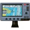
700 Series 788ci Combo NVB - Marine Chartplotter - 5" color - 640 x 640
-
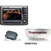
Package(E90W, GPS Antenna, DSM300G Sounder, 4KW 24 Inch Digital Radome & Radar Cable )
-
Colormax Wide 7 Panoramic LCD w/Internal Antenna
-
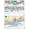
North Shore Long Island Sound, New Rochelle, New York to Norwalk, Connecticut Nautical Marine Charts, Large Print - Waterproof Charts
-
04-4006-000 Power I/O Cable f/Chart Master 11 & V6 Series
-
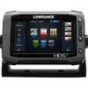
00010778001 HDS-7 Touch G2 Insight W-Lss
-
250C/50/200ST Transducer
-
10ft 24AWG CL2 Silver Plated High Speed HDMI Cable - Black
-
10ft Premium 3.5mm Stereo Male to 2rca Male 22AWG Cable 5599
-
EF1000iS - 900 Watt Inverter Generator
-
GPSMAP 4008 GPS Plotter with GPS Antenna 010-00591-00
-
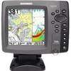
898c Si 7" Color Side Imaging Fishfinder/GPS