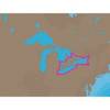
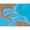
BlueChart g2 Vision - Southeast Caribbean - Maps
Model: Brand: Garmin
BlueChart g2 Vision offers the same rich detailed charting of BlueChart g2 to help you get the most out of your unit. In addition, g2 Vision features a growing database of high-resolution satellite imagery, above and below the water 3D perspective, auto guidance technology, aerial photographs for real world reference and coastal roads with points of interest. This product features coverage of the Caribbean from Haiti to Trinidad & Tobago, including Puerto Rico and all of the Lesser Antilles. Also includes the Colombian and Venezuelan coasts from Barranquilla, Colombia to the mouth of the Orinoco River, including Lake Maracaibo and the Gulf of Paria. « less
Product Specification
-
General
Product Type: MapsDistribution Media: SD Memory CardFirst Seen On Google Shopping: May 2007 -
Compatibility Information
Designed For: Garmin GPSMAP 4008, 4012, 420, 4208, 420s, 4212, 430, 430s, 430sx, 430x, 440, 440s, 440sx, 440x, 450, 5008, 5012, 520, 5208, 520s, 5212, 525, 525s, 530, 530s, 535, 535s, 540, 540s, 545, 545s, 550, 550s, 555, 555s -
Universal Product Identifiers
Part Numbers: 010-C0731-00, Southeast CaribbeanGTIN: 00753759069117, 00881094458805
Related Products
-
000-00099-007 - Sst-dfsblk, LSS-1
-
NA-C103 Furuno FP Format - Erie, Ontario & Trent Severn
-
NA-C402 Pensacola Bay to Honduras
-
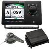
000-10577-001 AP70 Autopilot Pack w/AP70, AC70, RF300 & Require
-
White All-Round Light
-
1-1 4 in. IPS Intake Strainer Bronze Made in The USA
-
6ft 30AWG High Speed HDMI Cable - HDMI Connector to HDMI Mini Connector - Black
-
A06064 - SeaTalk NG 5-Way Connector Block
-
/ Quicksilver 84-79147A 3 P/T Pump Connector & Harness
-
F-Splice-CP/GH-01 Connector for RG-6U Cable
-
GPS 72 - Marine, hiking GPS receiver - Monochrome - 120 x 160
-
T70008 - e7D, 7 GPS/MFD/Sonar, US Inland Charts