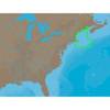
BlueChart g2 Vision - Mobile to Lake Charles - Maps
Model: Brand: Garmin
BlueChart g2 Vision offers the same rich detailed charting of BlueChart g2 to help you get the most out of your unit. In addition, g2 Vision features a growing database of high-resolution satellite imagery, above and below the water 3D perspective, auto guidance technology, aerial photographs for real world reference and coastal roads with points of interest. This product features Mobile, AL through Calcasieu Lake, LA, including New Orleans, the Mississippi River Delta, Lake Ponchartrain and Lake Maurepas, over to Vermilion Bay. « less
Product Specification
-
General
Product Type: MapsDistribution Media: SD Memory CardFirst Seen On Google Shopping: May 2007 -
Compatibility Information
Designed For: Garmin GPSMAP 4008, 4012, 420, 4208, 420s, 4212, 430, 430s, 430sx, 430x, 440, 440s, 440sx, 440x, 450, 5008, 5012, 520, 5208, 520s, 5212, 525, 525s, 530, 530s, 535, 535s, 540, 540s, 545, 545s, 550, 550s, 555, 555s -
Universal Product Identifiers
Part Numbers: 010-C0714-00, Mobile to Lake CharlesGTIN: 00753759068943
Related Products
-
SP-70MT Autopilot for Cable Steer Tilt Type Helms st70mt
-
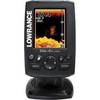
ELITE4X DSi Sonar
-
010-00484-04 - 6' Open Array for XHD Pedestal
-
FR8252 12.1 Color LCD 25KW 15 Mtr Cable No Antenna
-
NA-C301 Furuno FP Format Passamaquoddy ? Narragansett
-
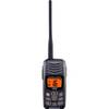
HX300 Handheld VHF Radio with USB Charger
-
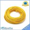
100ft 24AWG Cat6 550mhz UTP Ethernet Bare Copper Network Cable - Yellow
-
Cat6a Ethernet Cable | 2ft | Orange | Network | 10 Gigabit
-
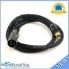
3ft Premier Series XLR Male to RCA Male 16AWG Cable (Gold
-
CONNECTOR, Female Tab 22-18 x .187 25 Per Package
-
A50 GPS / Chartplotter
-
RINO 520HCx - Hiking GPS receiver / two-way radio - Color - 176 x 220