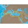
A27 Imray Antigua Marine Nautical Chart
Model: A27 Brand: Weems And Plath
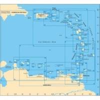
This Imray-Iolaire waterproof chart of Antigua Island includes large scale insets of Nonsuch Bay Mamora Bay Falmouth Bay and English Harbor. The chart is printed in color and uses official surveys and notes based on local knowledge. It is flat with no folds so is suitable for framing. Dimensions: 25 x 35 1/2 (640 x 900 cm). « less
Product Specification
-
Universal Product Identifiers
Part Number: A27
Related Products
-
JMA-5110 Black Box Radar 72NM, 10KW with 6 Foot Open Array (without LCD Display)
-
EM-M112 C-Card Format Aegean Sea
-
010-11572-00 - Sailboat Autopilot Drive Unit, Class A
-
2" Euro Black Series Fuel Level Gauge
-
DE6141 Floating Marine Handheld vhfradio
-
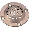
5" Round Bronze Strainer Made in The USA
-
Cat6a Ethernet Cable | 2ft | Orange | Network | 10 Gigabit
-
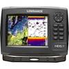
000-10531-001 HDS-7 Gen2 Insight USA w/o Transducer
-
230510 3 Way Connector 16-14
-
LTD 50HF1 50 Amp 125 Volt Female Connector
-
1ft 24AWG Cat6a 500mhz Stp Ethernet Bare Copper Network Cable - Blue
-
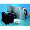
Barbour Air Cooled Power Plate PB100134