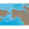
8264; Map-Clearlake/Lake Berryessa
Model: 8264 Brand: Fish-n-Map
FISH-N-MAP UNDERWATER TOPOGRAPHY MAPSMade of waterproof, tear resistant plastic. Features include: underwater depth contours, fish locations, latitude and longitude for GPS, multiple freshwater lakes on one map, boat ramps, recreational facilities and much more.
Product Specification
-
Universal Product Identifiers
Part Numbers: 235450, 8264, MSI432211GTIN: 00761428082640
Related Products
-
NA-C702 C-Card Format Nanoose - Victoria Cap
-
The Nautical Chart Movie Photo Print (11 x 17)
-
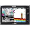
e165 15.4 Display Multifunction Inland Chart #E70025-IN
-
7ft 24AWG Cat5e 350MHz UTP Bare Copper Ethernet Network Cable - Pink
-
Cat6a Ethernet Cable | 5ft | Red | Network | 10 Gigabit
-
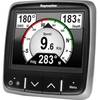
E22172 i70 Multifunction Instrument Display
-
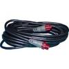
Marine Products Plug Wire Set 9-28054
-
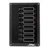
ACCY-IX Breaker Panel with Lights
-
000-0119-86 - N2K Extension Cable, Red Plugs, 15'
-
Cat6a Ethernet Cable | 50ft | Blue | Network | 10 Gigabit
-
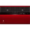
KWREDS Designer Colored Front for Sleeve Type S: Deep Red
-
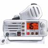
Eclipse DSC+ Fixed Mount VHF, Eclipse DSC 25W VHF Fixed White