4122 San Diego/Oceanside - Coronado
Model: 4122 Brand: Fish-n-Map
FISH-N-MAP UNDERWATER TOPOGRAPHY MAPSMade of waterproof, tear resistant plastic. Features include: underwater depth contours, fish locations, latitude and longitude for GPS, multiple freshwater lakes on one map, boat ramps, recreational facilities and much more.
Product Specification
-
Universal Product Identifiers
Part Number: 4122
Related Products
-
Video Sbmay3dvd DVD Mariners Guide to VHF Radar
-
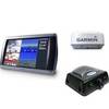
Radar 5215 Package with GMR24HD 4KW Radome & GSD22 Sounder
-
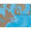
NA-C205 C-Card Format - Fundy Nova Scotia Pei Cape Br
-
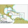
Cuba, Jamaica & The Cayman Islands: NT+ Wide Coverage by C-Map
-
Hydrographical Surveying. a Description of the Means and Methods Employed in Constructing Marine Charts. [Book]
-
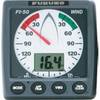
FI501 Wind Instrument Display - Head Only
-
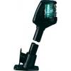
Powerboat Navigation Light, All Round Plug In, 48"
-
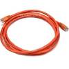
7ft 24AWG Cat6 500mhz Crossover Ethernet Bare Copper Network Cable - Orange
-
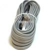
Phone Cable, RJ12 (6p6c), Reverse - 25ft for voice
-
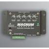
ME-AGS-N Automatic Generator Start
-
2ft 24AWG Cat6 550mhz UTP Ethernet Bare Copper Network Cable - Purple
-
Inc ETS014616912 Computer Hardware