010-C1025-10 Bluechart G2 HEU718LMediterranean Sea Data Card
Model: 010-C1025-10 Brand: Garmin
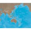
See your surroundings more clearly with BlueChart g2 data. With BlueChart g2, you'll get detailed marine cartography that provides convenient viewing of nautical content. BlueChart g2 allows you to see your vessel's precise, on-chart position in relation to naviads, coastal features, anchorages, obstructions, waterways, restricted areas and more. You will also have access to detailed mapping capabilities that include Safety Shading, Fishing Charts, smooth data transition between zoom levels, harmonious transition across chart borders, and reduction of chart discontinuities. Covers: Detailed offshore coastal coverage of the Mediterranean Sea in its entirety. Coverage features the Strait of Gibraltar, the Balearic Islands, the French Riviera, Corsica, Sardinia, Sicily, the Adriatic Sea, the Greek Islands, the Aegean Sea, the Dardanelles and Bosporus Straits, the Sea of Marmara, Cyprus, the Suez Canal, Tripoli and Algiers Harbors, and the Gulfs of Gabes and Tunisia. « less
Product Specification
-
Universal Product Identifiers
Part Numbers: 010-C1025-10, 10807287, 35821GTIN: 00753759096243
Related Products
-
1500 Autopilot with Rotary Feedback & 35 Deg Fluxgate Compass 10090019
-
AP2801VRF Autopilot AP28,AC12,RC42,NO Drive
-
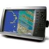
E97 Multifunction 9" Display with Sonar - aus, NZ, S. America, Asia Charts T70045 c44345
-
Package(E90W, GPS Antenna, RA1072HD 4KW 72 Inch HD Digital Open Array Radar & 15m Radar Cable )
-
AS-M001 SD Card Format Gulf of Thailand - Yellow Sea
-
010-C0772-10 Bluechart G2 HEU014RItaly Adriatic Sea Data Card
-
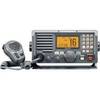
M604 Grey VHF Radio
-
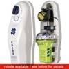
2875 Satellite 3 406 Cat II EPIRB
-
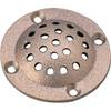
39161 Round Bronze Strainer, for Thru-Hull Size 1"
-
3ft RG6 (18AWG) 75OHM, Quad Shield, CL2 Coaxial Cable with F Type Connector - White
-
42-Pieces Heat Shrink Connector Kit BR51059
-
GPSMAP 4010 Plotter with GPS Antenna 010-00690-00