010-C1020-20 Bluechart G2 HXPC024RAustralia & New Zealand
Model: 010-C1020-20 Brand: Garmin
See your surroundings more clearly with BlueChart g2 data. With BlueChart g2, you'll get detailed marine cartography that provides convenient viewing of nautical content. BlueChart g2 allows you to see your vessel's precise, on-chart position in relation to naviads, coastal features, anchorages, obstructions, waterways, restricted areas and more. You will also have access to detailed mapping capabilities that include Safety Shading, Fishing Charts, smooth data transition between zoom levels, harmonious transition across chart borders, and reduction of chart discontinuities. Covers: Detailed coverage of the entire continent of Australia and New Zealand. Coverage includes Brisbane, Sydney, and the Great Barrier Reef along the Eastern coast. Coverage continues along the Southern coast including Melbourne, Adelaide, and Tasmania through the Great Australian Bight. Coverage also includes Perth, Geraldton, Darwin, and the Gulf of Carpentaria on the Western and Northern coasts. « less
Product Specification
-
Universal Product Identifiers
Part Numbers: 010-C1020-20, 10807238, 35814GTIN: 00753759095499
Related Products
-
385 Rudder Position Indicator
-
E12136 Autopilot Joy Stick
-
AIT1000 Class B Transponder w/GPS Antenna Incl
-
HDS-7 Gen2 Fishfinder GPS Chartplotter 53518700
-
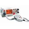
Mr F75 Fixed Mount Marine VHF Transceiver with Tri-Watch and Pa Capability - White, MRF75
-
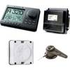
AP2804 Autopilot System AP28,AC42,RC42,RF300,RPU160
-
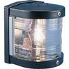
Series 25 Classic Starboard Navigation Light
-
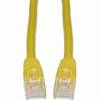
Cat6a Ethernet Cable | 5ft | Yellow | Network | 10 Gigabit
-
2896 3ft S-Video Cable DVD DSS SVHS Cable Svideo M/M (24K Gold Plated)
-
Split Connector 40ft Right Angle RJ45 Plug
-
LTD A3030Y50 50 Amp to 30 Amp Y Adapter
-
000-167-964 NMEA2000 Cable Light 6M D-End