010-C0730-10 Bluechart G2 HUS029RSouthern Bahamas Data Card
Model: 010-C0730-10 Brand: Garmin
Featuring data from explorere charts for the Bahamas! Detailed coverage from Eleuthera Island, Bahamas to the Dominican Republic, including the Bahamian islands of Great Exuma, Great Inagua, Mayaguana, and many others. Also includes detailed coverage of the Jamaican, Haitian, and Dominican coasts in their entirety, the easternmost quarter of Cuba, and the Turks and Caicos Islands. See your surroundings more clearly with BlueChart g2 data. With BlueChart g2, you'll get detailed marine cartography that provides convenient viewing of nautical content. BlueChart g2 allows you to see your vessel's precise, on-chart position in relation to naviads, coastal features, anchorages, obstructions, waterways, restricted areas and more. You will also have access to detailed mapping capabilities that include Safety Shading , Fishing Charts , smooth data transition between zoom levels, harmonious transition across chart borders, and reduction of chart discontinuities. « less
Product Specification
-
Universal Product Identifiers
Part Numbers: 010-C0730-10, 10469864, 35560, GAR010C073010GTIN: 00753759089313
Related Products
-
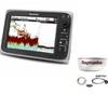
AP5005 Autopilot with AP50, J50, Rudder Feedback RF300, RPU300-12V Drive Unit
-
Package(c97 with USA Coastal Chart, 4KW 18 Inch Digital Radome & Radar Cable)
-
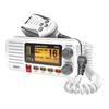
UN-UM415 - Fixed Mount VHF Marine Radio Whit
-
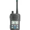
M-88 220V Handheld VHF Radio
-
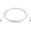
6ft 32AWG Mini DisplayPort Cable - White
-
1448 12ft Optical Toslink 5.0mm OD Audio Cable
-
PL-259-G Standard Marine Radio - Antenna Connector
-
Wiring Device-Kellems HBL63CM60 Connector Body,50 A 3d975
-
LTB-SS Light Bar Stainless Steel PYILTBSS
-
Inc ETS0131472 Computer Hardware
-
GP33 GPS with External Antenna and 4.3"Color Display
-
FasFind Max-G PLB w/ GPS