010-C0878-10 Bluechart G2 HAE003RTaiwan Data Card
Model: 010-C0878-10 Brand: Garmin
Covers mainland China from Macau to Shanghai, the Taiwanese coast in its entirety, and the Babuyan Islands to the south. Included in this overall general coverage are a number of detailed charts covering areas such as Chi-Lung, Tai., Kao-Hsiung, Tai., Shanghai, Chi., Xiamen, Chi., Guangzhou, Chi., and Hong Kong. See your surroundings more clearly with BlueChart g2 data. With BlueChart g2, you'll get detailed marine cartography that provides convenient viewing of nautical content. BlueChart g2 allows you to see your vessel's precise, on-chart position in relation to naviads, coastal features, anchorages, obstructions, waterways, restricted areas and more. You will also have access to detailed mapping capabilities that include Safety Shading , Fishing Charts , smooth data transition between zoom levels, harmonious transition across chart borders, and reduction of chart discontinuities. « less
Product Specification
-
Universal Product Identifiers
Part Numbers: 010-C0878-10, 10807014, 35777GTIN: 00753759090036
Related Products
-
Autopilot Joy Stick E12136 c15658
-
GPSMAP 441s GPS Combo T/M D/F Reman Noh
-
2-014 Outdoor US Northeast Chart for Endura Series
-
Marine ILIM4060 Auckland LED Reading Chart Marine Light
-
BlueChart g2 Vision - Baltic Sea, East Coast - Maps
-
Sea-King 1500-HD 15 HDTV Ready Satdome Map
-
788ci HD Di Combo Down Imaging w/TM Transducer
-
Video / audio extension cable - Female RCA phono x 2 to M RCA phono x 2
-
Spark Plug wire, r, 84-857124A 1
-
Marine Cowl Vent w/Hose Adapter F/3 BEC-C7
-
8166 LED 11/64" 230VAC, Red
-
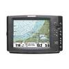
1100 Series 1155c NVB - Marine Chartplotter - 10.4" color - 800 x 600