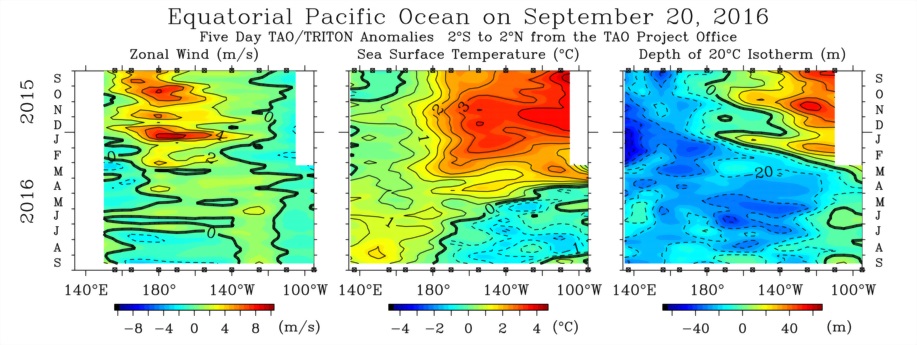
Sea surface temperatures in the central Pacific have been significantly below the seasonal average for the last 10 weeks, consistent with the formation of mild La Nina conditions.
But U.S. government forecasters have cut the probability of La Nina occurring this winter to 36%, down from an estimated probability of 76% at the time of their May forecast.
The U.S. government now predicts conditions this winter are likely to be neutral, with neither La Nina or El Nino evident, and puts this probability at 56%, up from 21% in May.
Surface temperatures in the central Pacific have cooled but not as fast or as far as expected earlier in the year, which has caused the forecast probability of La Nina developing to drop.
Many other phenomena associated with La Nina are either absent or only weakly present, which has also caused forecasters to downgrade their predictions.
Some models indicate a borderline La Nina this winter. But the consensus among U.S. forecasters is for neutral conditions based on the lack of significant support from other indicators.
The National Oceanic and Atmospheric Administration dropped its "La Nina watch" in September, having been on the lookout since April, according to the agency's latest forecast ("El Nino/Southern Oscillation diagnostic discussion", NOAA, Sept. 8).
El Nino
The term El Nino, meaning the boy, and referring to the infant Jesus, was originally employed by fishermen to describe an unusual warm southward current appearing each year in the cold waters off Peru just after Christmas.
The term El Nino, meaning the boy, and referring to the infant Jesus, was originally employed by fishermen to describe an unusual warm southward current appearing each year in the cold waters off Peru just after Christmas.
Every few years, the current is unusually intense and reaches further south, bringing heavy rains along the normally arid coast.
Years in which the warm current was unusually strong were known historically as anos de abundancia, or years of abundance ("El Nino, La Nina, and the Southern Oscillation", Philander, 1990).
The existence of the seasonal El Nino warm current was formally reported by scientists in the 1890s but it was not until the 1950s and 1960s that it was realised the warm surface waters extended far out into the ocean.
In fact, the exceptionally warm waters associated with anos de abundancia in Peru extend as far as the date line and are associated with unusually weak trade winds as well as heavy rainfall in the central Pacific.
El Nino has come to describe the presence of unusually warm waters throughout a stretch of the central and eastern Pacific and the associated weather phenomena over a much wider area.
The U.S. government now defines El Nino as sea surface temperatures at least half a degree Celsius warmer than the seasonal average, persisting for at least three months, in a specific region of the central-eastern Pacific.
The critical area of the ocean stretches from 120 degrees to 170 degrees west of Greenwich and straddles the equator from 5 degrees south to 5 degrees north.
Sea surface temperature anomalies in this area, known as Nino region 3.4, are the most closely correlated with all the other phenomena associated with El Nino.
Oceanographers later came to realise El Nino was the warm phase of an irregular cycle of sea surface temperatures. The cold phase came to be called La Nina, the girl.
La Nina, the opposite of El Nino, is associated with colder-than-normal waters off the coast of Peru stretching towards the date line and trade winds that are even stronger than usual.
South Oscillation
The Southern Oscillation was discovered separately by Gilbert Walker, working as director-general of the Indian Meteorological Department in the early 20th century.
Walker noted how pressure changes over the Pacific and Indian oceans were inversely correlated with one another as well as linked to the occasional failure of the Indian monsoon.
Walker observed that when atmospheric pressure at sea level was high in the Pacific it tended to be low in the Indian Ocean and vice versa, a cycle he named the Southern Oscillation.
The pressure swing was historically measured at observatories located at Darwin in Australia and Tahiti in the Pacific, both slightly south of the equator, but chosen for convenience because they are on land.
More modern measurements of the Southern Oscillation are usually taken by comparing sea level pressures over an area of Indonesia straddling the equator with one in the eastern Pacific.
Ocean-Atmosphere Coupling
Jacob Bjerknes at the University of California first proposed the link between El Nino and the Southern Oscillation in 1969. The combined cycle is now normally termed El Nino/Southern Oscillation, or ENSO.
Jacob Bjerknes at the University of California first proposed the link between El Nino and the Southern Oscillation in 1969. The combined cycle is now normally termed El Nino/Southern Oscillation, or ENSO.
Bjerknes suggested, and it was subsequently confirmed, that dry air sinks over the cold waters of the eastern Pacific (causing local high pressure) and flows west along the equator in the phenomenon known as the trade winds.
The air is warmed and picks up moisture as it flows across the ocean until it rises and forms rainclouds over the western Pacific (resulting in lower pressure there).
Drier air then returns across the Pacific in the upper atmosphere to sink again off the coast of Peru, completing a cycle Bjerknes called the Walker Circulation.
By warming the waters off Peru, El Nino weakens the trade winds and the Walker Circulation.
In contrast, the cold coastal waters of La Nina accelerate the trade winds and strengthen the Walker Circulation.
The Walker Circulation is therefore dampened and amplified by the difference in ocean temperatures between the eastern and western Pacific associated with El Nino and La Nina ("The Walker Cycle: ENSO's atmospheric buddy", NOAA, August 2014).
Trade Winds, Ocean Currents
Causality also flows the other way. El Nino and La Nina are themselves initiated and amplified by the weakening and strengthening of the trade winds and the Walker Circulation.
Trade winds carry warmer surface water from the coast of Peru far out into the Pacific in a fast-flowing equatorial current that can carry water towards the date line at speeds exceeding 1 metre per second.
As the warmer surface waters are driven off by the trade winds they expose and are replaced by an upwelling of colder water from the deep ocean.
When the trade winds accelerate, as in La Nina, the waters off the coast of Peru cool even more than normal and the cold zone extends further out into the ocean. When the winds slacken, as in El Nino, the waters off the coast of Peru become warmer.
The ocean cycle of El Nino and La Nina is coupled with the atmospheric Walker Circulation and Southern Oscillation, and the two interact closely with one another.
La Nina describes the opposite set of ocean-atmosphere interactions, with stronger trade winds cooling the eastern Pacific more than normal, which in turn drives stronger trade winds.
Positive Feedback Loops
El Nino and La Nina are examples of positive feedback mechanisms in the coupled ocean-atmosphere circulations.
El Nino and La Nina are examples of positive feedback mechanisms in the coupled ocean-atmosphere circulations.
El Nino/La Nina and the Southern Oscillation are instances of a complex system in which small changes in either trade winds or sea surface temperatures can trigger large climate changes through feedback.
The sensitivity of ENSO to small variances in atmospheric or oceanic conditions is one reason why the timing, strength and development of El Nino/La Nina episodes are hard to forecast.
It also explains why the accuracy of predictions deteriorates rapidly when the forecast horizon extends forward by more than a few months, which is why NOAA has had to scale back its La Nina prediction since May.
Although El Nino and La Nina are defined by reference to sea surface temperature anomalies, they are associated with a host of supportive changes in sea-level pressure, wind speed and convection.
Sea surface temperature, sea level pressure, wind speed and convection anomalies are all closely though not perfectly correlated with each other ("Why are there so many ENSO indexes?" NOAA, January 2015).
But El Nino/La Nina and the Southern Oscillation are not the only influences on ocean and atmosphere circulations in the Pacific, so positive feedback mechanisms can fail to develop or subsequently break down.
In the current episode, the moderate cooling of waters in the eastern Pacific has not so far been accompanied by a strong and supportive pickup in pressure anomalies and trade winds.
Without a pickup in pressure anomalies and wind speeds, the positive feedback mechanisms that drive La Nina are absent or only weakly present.
The lack of positive feedback as shown in other indicators of sea level pressures and wind speeds is why forecasters have become much less confident about the emergence of La Nina during the winter of 2016/17.
(By John Kemp)