![AVCS+ARCS screenshots[1].png](https://www.marineelectronics.com/images/avcs~2barcs-screenshots~5b1-60277.png)
Raster charts and ENCs offer “best of both worlds” says UKHO .
Together, the ADMIRALTY Vector Chart Service (AVCS) and ADMIRALTY Raster Chart Service (ARCS) give you easy access to the world’s widest suite of official digital charts. Ideal for both planning and navigation, they can help simplify operational tasks and improve situational awareness.
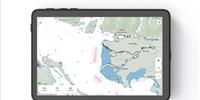
Raster charts are digital versions of paper charts and contain exactly the same information as their paper equivalents. ARCS comprises over 3,000 digital raster copies of official ADMIRALTY paper charts and is ideal for back-office functions, such as passage planning, voyage monitoring and incident management, whether on board or on shore.
ARCS charts display exactly the same imagery and symbols as traditional paper charts, meaning that they are immediately familiar to the mariner. ARCS charts are also compatible with a wide range of ECDIS and ECS navigation systems, where they can be combined with accurate satellite positioning. ARCS also works well alongside an official ENC service such as AVCS, combining the familiarity of paper charts with the digital benefits of fast, accurate automatic updates to provide mariners with the information they want and need.
Jason Scholey, Senior Product Manager - Charts, UKHO, commented: “Although they are different formats, ENCs and raster charts can provide the best of both worlds when used together. For the mariner, a raster chart can be a valuable navigational aid to simplify operational tasks and improve situational awareness. For example, at large scale a raster chart can provide important information such as dredged depths and berth names that can be harder to find in the equivalent ENC.
“ARCS combines the traditional strengths of paper charts with the modern benefits of a digital format, with familiar images and symbols instantly recognisable to generations of professional mariners.
“By combining the familiarity and ease-of-use of ARCS with an ENC service like AVCS, shipping companies will get the most comprehensive and trusted official digital chart service available for internationally trading ships. Subject to individual Port and Flag State control, ARCS can also be used as a safe and reliable primary navigation alternative to AVCS under certain circumstance, for example where an appropriate scale ENC doesn’t yet exist."
Available as a world folio, a series of regional folios or on an individual, chart by chart basis, ARCS contains over 3,000 charts, including major ports, harbours and international shipping routes in a comprehensive range of scales. ARCS charts are official Raster Navigational Charts, as defined by the IHO, and can be accurately updated in seconds with a free weekly update service that saves time and reduces the risk of errors. ARCS is also supported by ADMIRALTY e-Navigator Planning Station, a free chart ordering and management tool, as well as on office-based display systems and software, making it a valuable shore-based fleet management tool.