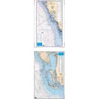
Waterproof Charts 15F Southwest Florida FISH/DIVE
Model: 15F Brand:
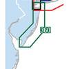
15F SOUTHWEST FLORIDA FISH/DIVEComplete offshore coverage from Tampa Bay south to 50 Miles South of Marco Island. Reverse side is coastal coverage from Englewood south to Ft. Myers Beach with complete depths for Charlotte Harbor, Pine Island Sound and Matlacha Pass. A table recompiled in FALL of 1999 contains a total of 209 Plotted and Indexed GPS/LORAN WAYPOINTS for Reefs and Wrecks, Lights and Fishing and Diving Areas. Information from 2 NOAA Charts; 11426 & 11420.25 x 38 « less
Product Specification
-
Universal Product Identifiers
Part Number: 15F
Related Products
-
Scp 110 Autopilot Course Computer Rate Gyro
-
116-05 M68C S/Map - No Transducer 116-052
-
Waterproof Chart Kit - New Jersey Coast #WPB0360-02
-
Max PC-M203 W69 Carolinas,Kiribati, Marshall-MAX
-
061 15 Parallel Rules
-
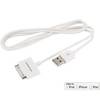
3ft USB Sync Cable for All 30-pin iPad, iPhone, and iPod - White
-
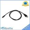
USB 2.0 A Male to Micro-B Male Cable 3 ft.
-
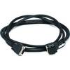
8ft db9/data Token Ring Cable
-
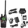
NT3VP Nautico Waterproof Marine Radio mdlnt3vp
-
16 Inch Aft Power Mount Simrad Light Bracket Option PMA-16N-7L (PMA-167-M1 + ADA-R1)
-
1ft 24AWG Cat5e 350MHz UTP Bare Copper Ethernet Network Cable - Green
-
RINO 130 - Hiking GPS receiver / two-way radio - Monochrome - 160 x 160